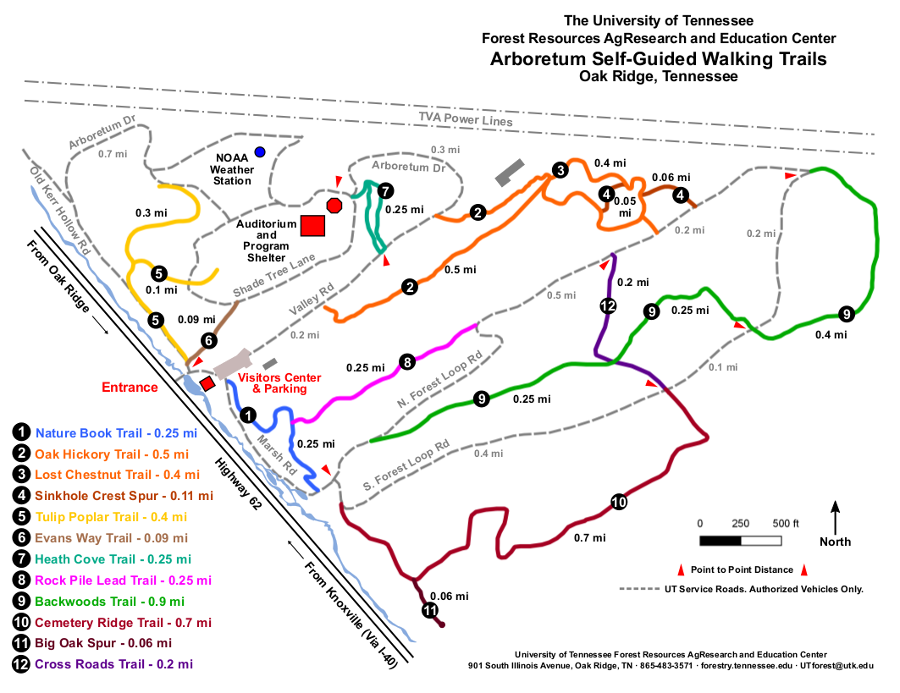
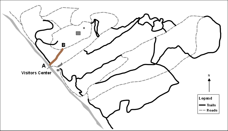
UT Arboretum Trails Map printable – There is also a QR code on the trail map box at the Welcome Kiosk by the Visitors Center.

- Trail length: 0.25 miles
- Round trip: 0.5 miles
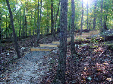
Our new Nature Book Trail consists of 14 large signs that display the pages of Butterflies: Exploring the Life Cycle, a book by Oak Ridge author and educator Dr. Shirley Raines and University of Memphis nature photographer Curt Hart. The trail begins near the entrance to the Visitors Center and ends at Marsh Road that comes back to the starting point. In all, the distance is about 0.5 mile, and is suitable for adults and children who can walk. The trail is neither handicap accessible nor suitable for baby strollers.
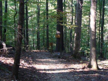
Formerly named the White Pine Trail, the Nature Book Trail is on the hillside above the meadow that borders Scarborough Creek. The trail winds through what was once an eminent stand of tall eastern white pine trees. Most are gone now, destroyed by the Southern Pine Beetle epidemic in 2003. The American beech trees that have grown into the area where the pines once stood will stand out in the winter months, as many of their faded-orange fall leaves are retained until spring. On the way back to the Visitors Center along Marsh Road, early spring walkers will enjoy the colorful blooms in the Magnolia Garden on the slope above the road.
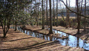
The Marsh Area is located where Scarborough Creek widens – just south of the grassy meadow. The bright red berries of the Marsh Area collection of hollies will treat fall and winter visitors. Walkers in all seasons will enjoy the “trees with knees” (bald cypress) in the marsh and the Central China Collection of tree specimens that are found in remote areas of China. An informative sign, located in that area, describes the characteristics of the water-loving trees growing in the marsh.
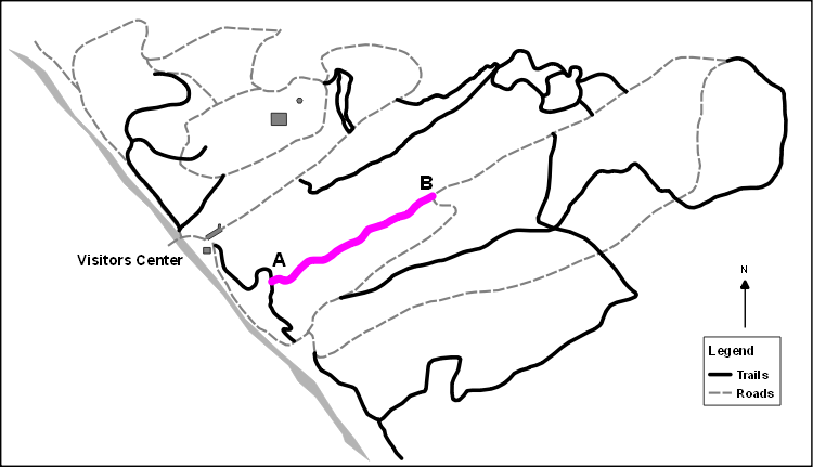
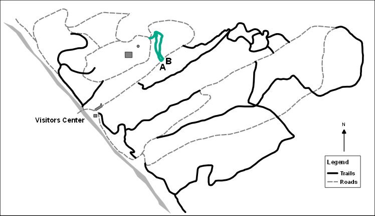
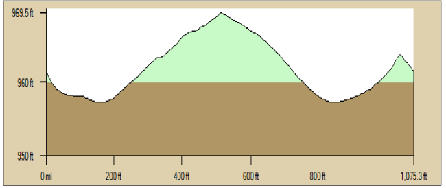
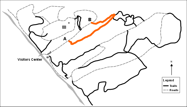
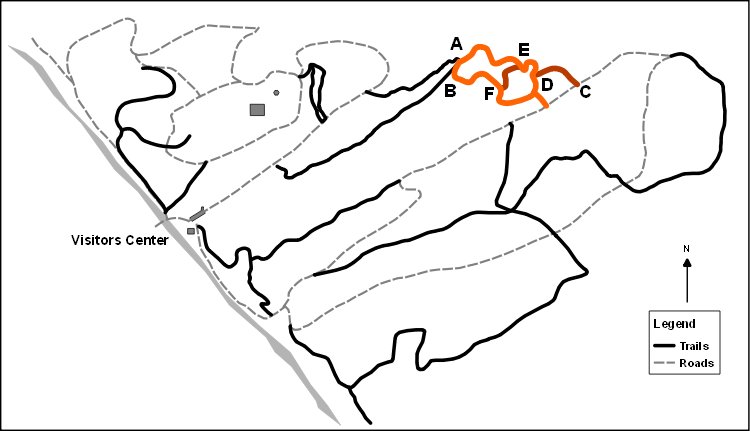
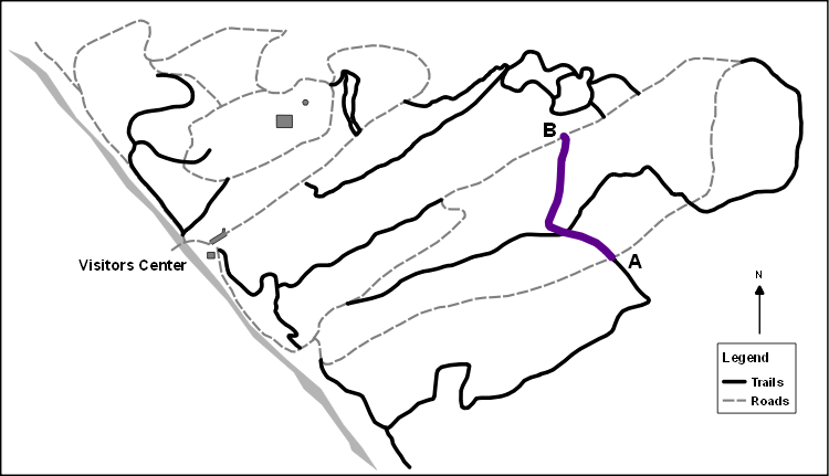
Map and Profile
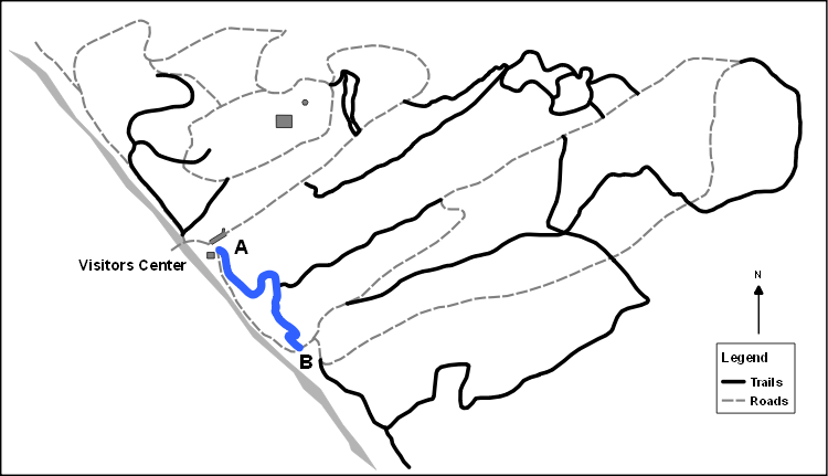

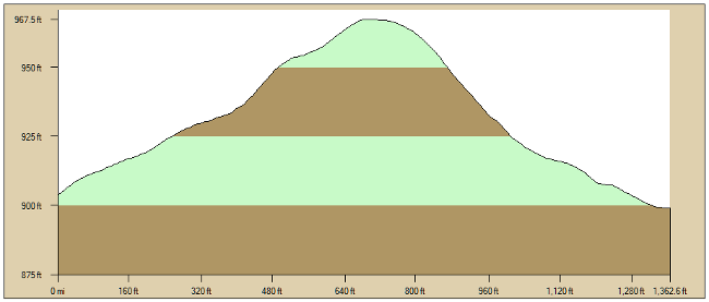
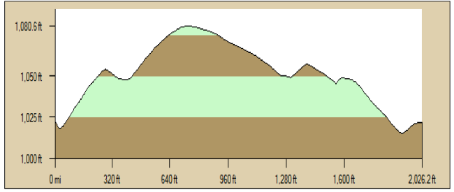
Nature Book Trail Profile (A to B)
GPS at A: N35.99158, W84.21822
Average Grade: 9%
Distance: 1,362.6 ft.
Profiles generated with DeLorme XMap.
- Trail length: 0.25 miles
- From Visitors Center via White Pine Trail: 0.35 miles
- Round Trip: 0.7 miles
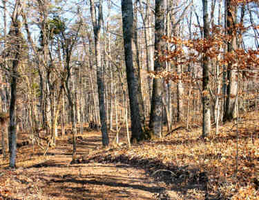
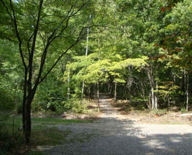
Rock Pile Lead starts about half way along the White Pine Trail and winds up the ridge to end at the North Forest Loop road. Although it ascends the ridge, the slope is not steep. Initially it passes through a forest dominated by large beech (Fagus grandifolia) trees. Farther along White and Black Oak (Quercus alba and Quercus velutina) become prominent, along with a mixture of other deciduous trees typical of Oak-Hickory forests (e.g., sourwood, dogwood). A few pines are also present reflecting a history of past disturbance. Conspicuous features along the trail are piles of rocks which were accumulated by settlers as they cleared the area for pastures and crops. Several yucca plants can be seen toward the upper end of the trail.
Map and Profile
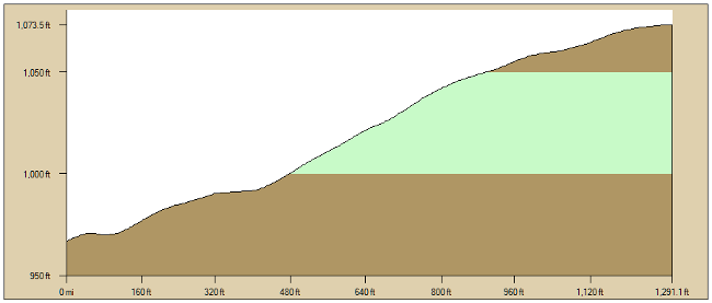
Rock Pile Lead Trail Profile (A to B)
GPS at A: N35.99470, W84.21524
Average Grade: 8%
Distance: 1291.1 ft.
Profiles generated with DeLorme XMap.
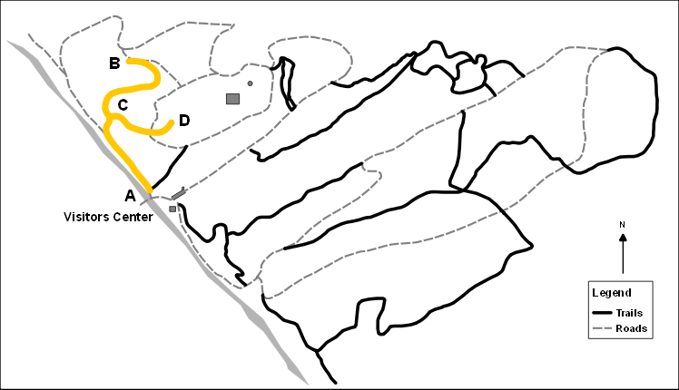
- Trail length: 0.4 miles
- Major Plant Collections length: 0.25 miles
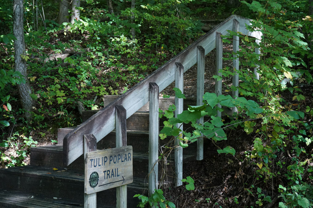
The Tulip Poplar Trail begins off of the Arboretum main entrance road and parallels an access road, Old Kerr Hollow Road, before turning into a stand of pine and oak trees. These are second growth trees, as this area was once farmed. There is also evidence that the area was damaged by fire. The pines are shortleaf pine and Virginia pine. The oaks include white oak, northern red oak, black oak, and scarlet oak. Sassafras is also common along this trail. But it is the tulip poplar that stands out. An aggressive pioneer species, the tulip poplars on the slope above the trail were originally seeded into cultivated fields that had been abandoned.
A spur of the Tulip Poplar Trail leads to an open field area. Across the field is the Shrub Garden which takes walkers into the heart of the Arboretum’s major plant collections area. Our Major Plant Collections Map shows the locations of shrubs, conifers, junipers, and shade trees. The Elmore Holly Garden, a collection of over 200 holly cultivars, is just to the east of the Program Shelter.
Map and Profile
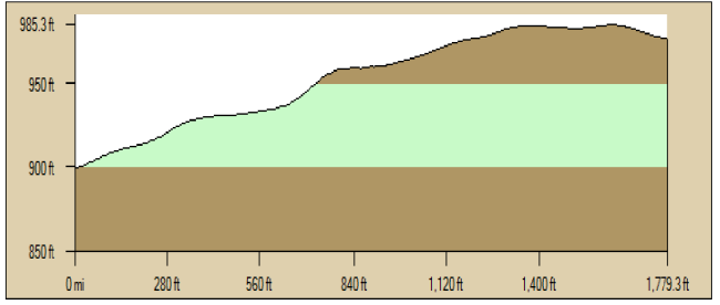
Tulip Poplar Trail Profile (A to B)
GPS at A: N35.99733, W84.22121
Average Grade: 5%
Distance: 1779.3 ft.

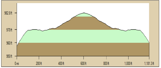
Tulip Poplar Spur Profile (C to D)
GPS at A: N35.99589, W84.22166
Average Grade: 4%
Distance: 1181.3 ft.
Profiles generated with DeLorme XMap.
- Trail length (Upper and Lower): 0.25 miles
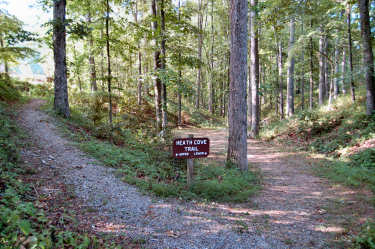
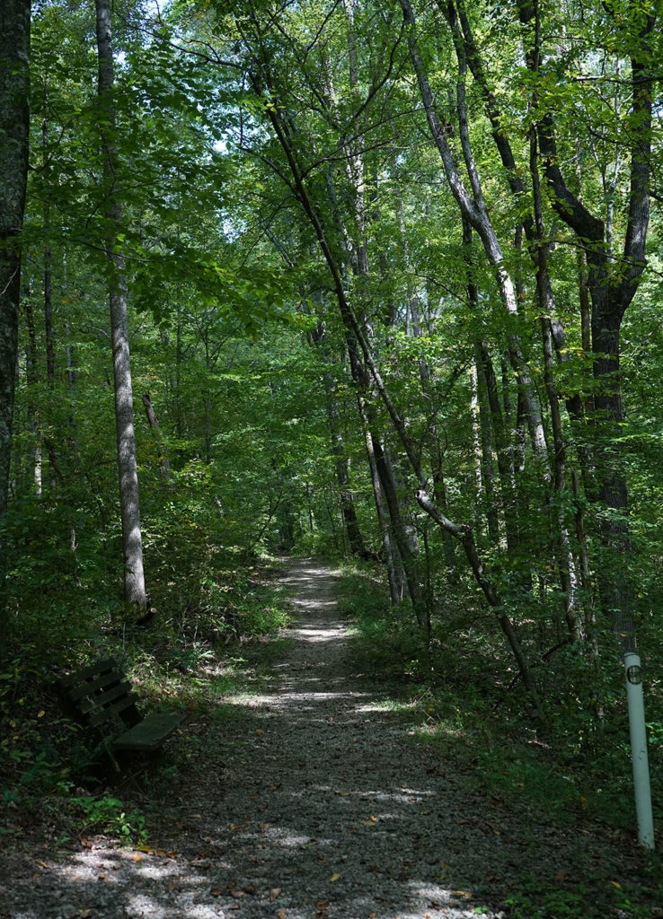
The Heath Cove is a demonstration project begun in the late 1960s to showcase members of the heath family. Spring walkers will find a display of brilliant-colored azaleas and rhododendrons – the more showy members of the heath family. Other heaths include laurel, andromeda, sourwood, trailing arbutus, huckleberry, and blueberry. The trail is divided into the Upper Heath Cove and the Lower Heath Cove with each presenting walkers a unique experience.
Map and Profile
Heath Cove Trail Profile (A to B)
GPS at A: N35.99607, W84.21703
Average Grade: 3%
Distance: 1075.3 ft.
Profiles generated with DeLorme XMap.
- Trail length: 0.9 miles
- From Visitors Center via N. Loop Road: 0.3 miles
- Round Trip via S. Loop Road: 2.1 miles
Just beyond the Marsh Area, a graveled path leads to the Forest Loop Road. A fork divides this road into the North Forest Loop and the South Forest Loop. The lower entrance to the Backwoods Trail is up a rather steep climb along the North route. The South route is a more gradual rise leading to another entrance to the Backwoods Trail. Aptly named, this trail traverses through some of the more remote areas of the Arboretum. But walkers are rewarded with a quiet, deep woods experience. There are several choices for return routes to the Visitors Center, including, along the South Forest Loop, around the North Forest Loop, or via the Lost Chestnut Trail to Valley Road.
Parts of the Forest Loop area were formerly a pastureland which was abandoned and subsequently returned to natural forest. Pines are among the first to grow in such an area but are eventually replaced by hardwoods as time passes. This area has also experienced storm damage and some of the pines were killed by the Southern Pine Beetle. These areas are examples of natural re-forestation.
Map and Profile
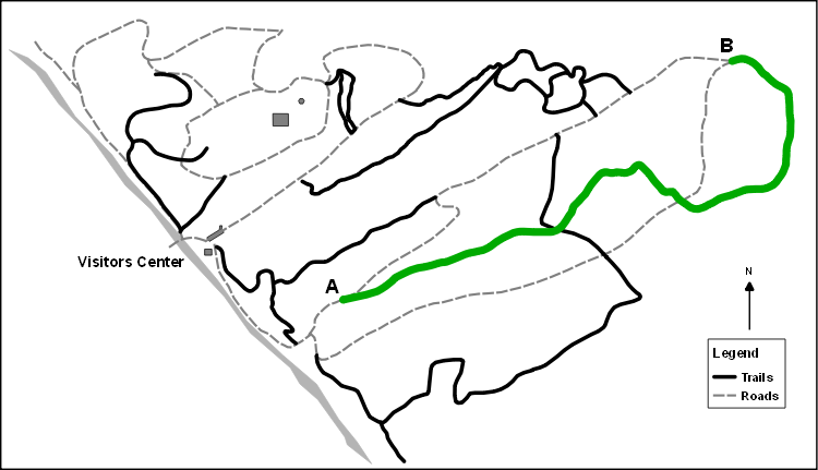
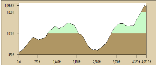
Backwoods Trail Profile (A to B)
GPS at A: N35.99765, W84.20892
Average Grade: 6%
Distance: 4681.3 ft.
Profiles generated with DeLorme XMap.
- Trail length: 0.5 miles
- From Visitors Center to trail: 0.1 miles
- Round trip: 1.1 miles
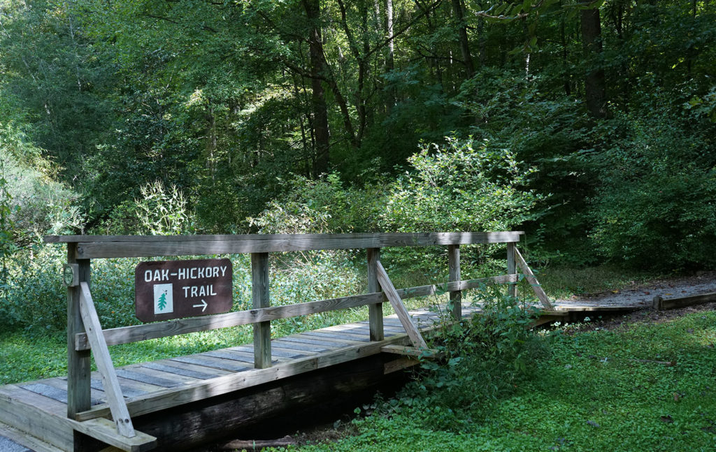
The entrance to this trail is off Valley Road, just above the Visitors Center. The Oak-Hickory Trail takes visitors through stands of oak and hickory, the dominant trees in this forest type. Oaks include, white oak, northern and southern red oak, black oak, scarlet oak, and chestnut oak. Mockernut and pignut hickory are prevalent along the trail, while shagbark and bitternut hickory may occasionally be found elsewhere on the Arboretum.
Before the chestnut blight destroyed most of the American chestnuts, this type of forest was dominated by oaks and chestnuts. Since the chestnut blight was gradual, hickories slowly took over where chestnuts had died. In the spring, numerous wildflowers can be seen along the trail. Trees have been labeled along the first part of the trail to help visitors identify common species. Trees along the final part of the trail have been numbered to provide visitors an opportunity to test their identification skills. Your identifications can be verified at the Visitors Center. The route back to the Visitors Center via Valley Road goes past the Dwarf and Unusual Conifer Collection.
Map and Profile
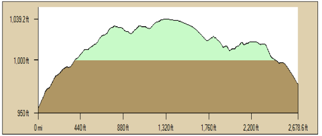
Oak Hickory Trail Profile (A to B)
GPS at A: N35.99677, W84.21598
Average Grade: 7%
Distance: 2534.8 ft
Profiles generated with DeLorme XMap.
- Trail length through Lost Chestnut Trail loop: 0.05 miles
- Trail length Sinkhole Crest Spur through Lost Chestnut Trail loop: 0.05 miles
- Trail length from Lost Chestnut Trail to N. Forest Loop road: 0.06 miles
- Round Trip from Visitors Center via Oak Hickory Trail: 1.2 miles
The entrance to the trail and spur is via the Oak-Hickory Trail entrance off Valley Road, just above the Visitors Center. The Lost Chestnut Trail makes a loop above the Oak Hickory Trail, starting at a kiosk about half way along the Oak-Hickory Trail. This trail was originally developed to provide an opportunity for visitors to observe surviving traces of the once abundant and majestic American chestnut tree. The only reminders of this once magnificent forest tree were old decaying stumps and logs. Today, even these remnants have disappeared. Although the types of trees along this trail are similar to those of the Oak-Hickory Trail, large chestnut oak trees are conspicuous dominants. The trail passes along the edges of several sinkholes, which can be viewed more closely on the Sinkhole Crest Spur Trail. The Lost Chestnut loop ends at the kiosk where walkers can rejoin the Oak-Hickory Trail and return to Valley Road. The Dwarf Conifer Collection is along the route back to the Visitors Center.
Map and Profile
Lost Chestnut Trail Profile (A to B)
GPS at A: N35.99746, W84.21379
Average Grade: 8%
Distance: 1988.1 ft.
Sinkhole Crest Spur Profile (C to D)
GPS at C: N35.99795, W84.21108
Average Grade: 1%
Distance: 379.1 ft.

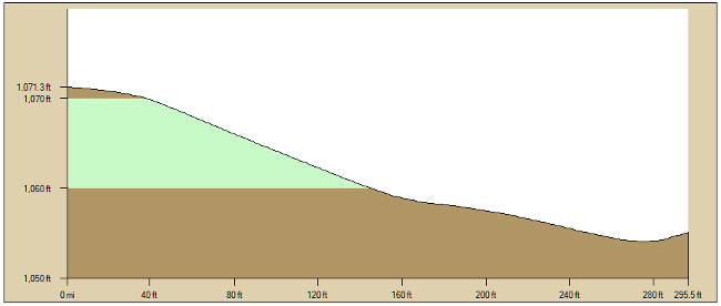
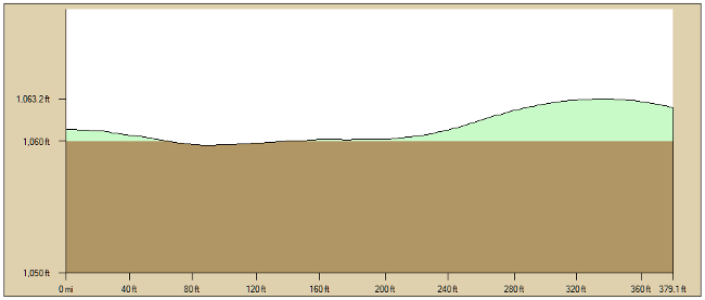
Sinkhole Crest Spur Profile (E to F)
GPS at C: N35.99733, W84.21237
Average Grade: 6%
Distance: 295.5 ft.
Profiles generated with DeLorme XMap
- Trail length: 0.7 miles
- From Visitors Center via S. Loop Road: 0.25 miles
- Round trip via S. Loop Road: 1.6 miles
- Big Oak Spur length: 0.06 miles
| This trail was named by David Scanlon of Knoxville who submitted the winning entry in a contest held to name the trail when it was blazed in 2008. The contest entry form asked participants to explain “Why I think this is a fitting name.” David wrote, “The trail follows the top of a scenic ridge with views to the southwest of a cemetery below. The cemetery will be visible at least six months of the year. This pretty ridge near the river could also have been the site of Indian graves some two hundred years ago.” Richard Evans, former UT Arboretum Director, embellished Mr. Scanlon’s story with his observations, “Many years ago I found two rectangular depressions in the ground under an old oak tree on the top of this ridge. Around these depressions there were some old grass edging strips and metal flower pots. The depressions are side by side and oriented East-West, the traditional orientation of a burial plot. There were no grave markers, but the evidence indicated that these depressions may have been graves. I speculate that if they were graves, possibly the folks interred there may have been moved when the Government bought all of the property in Oak Ridge in 1941-42 to begin the Oak Ridge Manhattan Project. Thus, Cemetery Ridge Trail might be even a more fitting name than Mr. Scanlon realized.” Over a decade later, a new spur was blazed to showcase a very large white oak tree located off of the Cemetery Ridge trail. |
Map and Profile
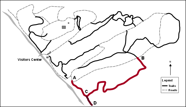
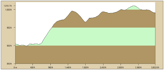
Cemetery Ridge Trail Profile (A to B)
GPS at A: N35.99349, W84.21164
Average Grade: 5%
Distance: 3802.8 ft.
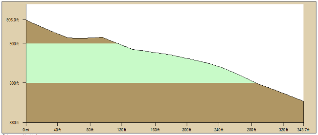
Big Oak Spur Profile (C to D)
GPS at A: N35.98906, W84.21590
Average Grade: 6%
Distance: 343.7 ft.
Profiles generated with DeLorme XMap.
- Trail length: 0.2 miles
- From Visitors Center via S. Loop Road: 0.65 miles
- From Visitors Center via N. Loop Road: 0.7 miles
- Round trip via S. Loop Road: 1.55 miles
The Cross Roads Trail links the North and South Forest Loop Roads. Starting at its intersection with the Cemetery Ridge Trail along the South Forest Loop Road, the trail is relatively flat which makes for easy walking. Initially, the trail passes through relatively young forest with many fallen pines that were killed by the southern pine bark beetle several years ago. The presence of these pines speaks to past land use when the area had been cleared for pasture. Red maples and sourwood are among the more conspicuous members of the forest cover.
Approximately one-third of the way long this short trail, it intersects with the expanded Backwoods Trail. Two benches provide a quiet resting spot where one can sit and absorb the serene forest setting and enjoy both plant and animal life. At this intersection, walkers can turn south along the new section of the Backwoods Trail which eventually meets the North Forest Loop Road, turn north to access the older section of the Backwoods Trail, or proceed west along the Cross Roads Trail. The terrain gradually steepens for a short distance through a section of forest that is relatively open. Maples, sourwoods, oaks, and hickories are prominent members of this forest community.
As one approaches the trail’s end, where it joins the North Forest Loop Road, the terrain levels out and the walking is easy. There is also a bench located at this intersection. Turning south on the North Forest Loop Road, walkers can return to the Visitors Center via the Marsh Area. A north turn along the road quickly leads to an intersection with the Lost Chestnut Trail.
Map and Profile
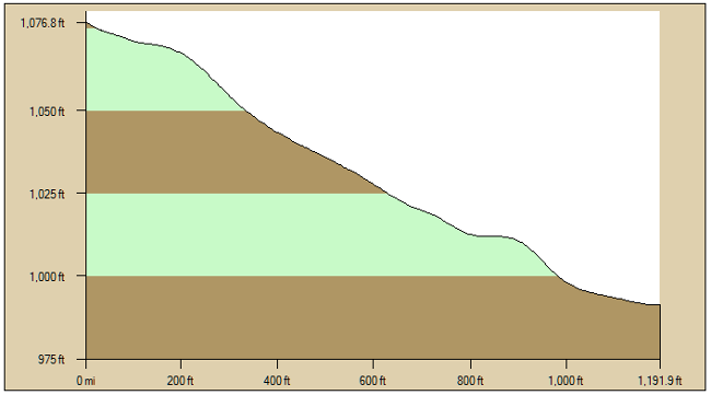
Cross Roads Trail Profile (A to B)
GPS at A: N35.99604, W84.21265
Average Grade: 7%
Distance: 1191.9 ft.
Profiles generated with DeLorme XMap.
- Trail length: 0.09 miles
- Round trip: 0.18 miles
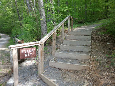
The UT Forest Resources AgResearch and Education Center/UT Arboretum officially opened the Evans Way Trail on Monday April 16, 2018. The new trail was dedicated and named in honor of Richard and Carol Evans who spent over 35 years living on the UT Arboretum property. The Evans Way Trail follows the path of the UT Arboretum Auditorium water line/fiber optic cable route that starts out on Old Kerr Hollow Road and terminates at the top of the hill on Shade Tree Lane. The new 500’+ connector trail takes the hiker through a mature oak-pine forest and provides the shortest trail access to the auditorium grounds from the UT Arboretum main parking lot. Mr. Evans retired as the Director of the UT Forest Resources AgResearch and Education Center after 39+ years in June of 2011 and remained in a post-retirement position until December of 2011. Our clientele has greatly benefited from the work, special projects, and trail system that Mr. Evans planned, coordinated, and completed during his life-long career serving the UT Institute of Agriculture.
Map and Profile
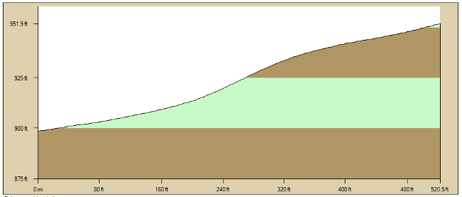
Evans Way Trail Profile (A to B)
GPS at A: N35.99543, W84.21943
Average Grade: 10%
Distance: 520.9 ft.
Profiles generated with DeLorme XMap.