Kerr Hollow Heritage Trace
The UT Arboretum’s Kerr Hollow Heritage Trace is a tribute to the families who lived within this area of Oak Ridge, TN, now part of the UT Arboretum, before the land was purchased in 1942 for development of the Manhattan Project.
The word “hollow” was the name local people gave to this valley through which the Scarbrough Creek runs. The valley completely bisects Chestnut Ridge. In geology terms, this type of valley is referred to as a “water gap.” Chestnut Ridge lies between Union Valley to the North and Bethel Valley to the South. Kerr Hollow is drained by Scarbrough Creek, which eventually empties into the Clinch River and along its meandering path passes through the site of the old community of Scarbrough.
Kerr Hollow derived its name from the Kerr family, whose farm and homestead were located along the creek. The section of State Route 62 that runs along the UT Arboretum was originally named Kerr Hollow Road, but in 2001 the city of Oak Ridge renamed it South Illinois Avenue.
According to accounts from Kerr family descendents, Joe Lee Kerr and his wife Mary Mollie Walters Williams Kerr bought the 140 acre farm in March of 1925 from a real estate firm in Knoxville for $14,000. Before the purchase, the Kerr’s and five of their children had lived in Corbin, Kentucky where Joe Lee worked for the L & N railroad. After coming to this area, two more children were born.
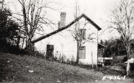
In addition to the properties owned by Mollie Kerr and her brother J.L. Kerr, five other families owned property in the hollow, contained within the UT Arboretum grounds, when the area was purchased by the government in 1942. The Clyde E. Foster house was located on the site of the present day UT Arboretum Visitors Center and the J. Walters Taylor property was located just below the Foster house. The Taylor house, a log cabin style structure dating from the late 1830s, was originally owned by the Winchester family. The Foster house was previously owned by the Gorman family. Gorman and Winchester family photos taken during the 1920’s period were provided by descendents and are on display in the lobby of the UT Arboretum Visitors Center. Farther up the hollow from the Visitors Center was the Josie Robinson farm and up and across the road was the W.R. Scarbrough family. Scarbrough (also spelled Scarboro) Creek bears the family’s name. The H.H. Hackworth property was located across the road from the Kerr farm.
Descriptions and photos of all of the properties – taken at the time they were purchased by the government for the Manhattan Project – can be viewed on the Historical Photo Gallery page. A link to a 1942 aerial photo and map of the property locations can be found on the Kerr Hollow Map page.